Transect Collection
Photographed by Sandy Sorlien
Sponsored by the Center for Applied Transect Studies
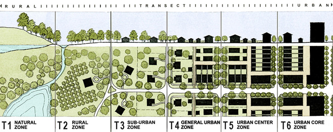
Transect diagram courtesy of DPZ & Co.
ABOUT THE TRANSECT
A natural transect is a slice or path used by ecologists to sample and analyze the natural environment in a particular location. A rural-to-urban transect is a similar sampling sequence used by urban planners in the built environment. The model Transect, which is always calibrated locally, is shown in the diagram above. Transect Zones are intended to replace conventional separated-use zoning, and are applied at the fine grain of several T-zones per neighborhood. Learn more about transect-based planning here.
ABOUT THE COLLECTION
The Transect Collection was created to advance the field of transect-based planning and strengthen its common language. The rural-to-urban Transect has been an important framework for urbanism for twenty years. The Collection provides an image resource that is both concise and authoritative.
The Collection is freely available for educational use. It may be projected live into the classroom or charrette room to support a lecture, or searched for specific subjects. To request an individual image, write to Sandy at [email protected]. Images are organized into galleries – one for each of the six Transect Zones, plus Civic Buildings, Civic Spaces, Thoroughfares, Transit & Bicycling, Special Districts, Aerials, and Metrics Illustrated. Within each gallery, the cities appear in alphabetical order. Subjects and places, including regions, may be searched by clicking on keywords or using the Search field.
The "Local Transect" gallery assembles images from several cities into Transect sequences so you don't have to assemble them yourself.
ABOUT THE PHOTOGRAPHER
Sandy Sorlien has had a 30-year career teaching photography and documenting the built environment. She received three Fellowships in Photography from the Pennsylvania Council on the Arts, and is the author of Fifty Houses: Images from the American Road (Johns Hopkins 2002). In 2005 Hurricane Katrina was the impetus for a career change, as Sandy's part-time work in New Urbanism turned full-time in Mississippi and New Orleans. She has since edited and managed numerous transect-based planning tools, including the model Smartcode, the model Neighborhood Conservation Code and the multi-disciplinary Module toolkit by 40-plus authors. The Transect Collection represents the merging of these two career paths.
ABOUT THE SPONSOR
The Center for Applied Transect Studies (CATS) promotes understanding of the built environment as part of the natural environment, through the planning methodology of the rural-to-urban transect. CATS supports interdisciplinary research, publication, tools and training for the design, coding, building and documentation of resilient transect-based communities.
Please credit all uses: ©Sandy Sorlien from www.transect-collection.org
Photographed by Sandy Sorlien
Sponsored by the Center for Applied Transect Studies
Transect diagram courtesy of DPZ & Co.
ABOUT THE TRANSECT
A natural transect is a slice or path used by ecologists to sample and analyze the natural environment in a particular location. A rural-to-urban transect is a similar sampling sequence used by urban planners in the built environment. The model Transect, which is always calibrated locally, is shown in the diagram above. Transect Zones are intended to replace conventional separated-use zoning, and are applied at the fine grain of several T-zones per neighborhood. Learn more about transect-based planning here.
ABOUT THE COLLECTION
The Transect Collection was created to advance the field of transect-based planning and strengthen its common language. The rural-to-urban Transect has been an important framework for urbanism for twenty years. The Collection provides an image resource that is both concise and authoritative.
The Collection is freely available for educational use. It may be projected live into the classroom or charrette room to support a lecture, or searched for specific subjects. To request an individual image, write to Sandy at [email protected]. Images are organized into galleries – one for each of the six Transect Zones, plus Civic Buildings, Civic Spaces, Thoroughfares, Transit & Bicycling, Special Districts, Aerials, and Metrics Illustrated. Within each gallery, the cities appear in alphabetical order. Subjects and places, including regions, may be searched by clicking on keywords or using the Search field.
The "Local Transect" gallery assembles images from several cities into Transect sequences so you don't have to assemble them yourself.
ABOUT THE PHOTOGRAPHER
Sandy Sorlien has had a 30-year career teaching photography and documenting the built environment. She received three Fellowships in Photography from the Pennsylvania Council on the Arts, and is the author of Fifty Houses: Images from the American Road (Johns Hopkins 2002). In 2005 Hurricane Katrina was the impetus for a career change, as Sandy's part-time work in New Urbanism turned full-time in Mississippi and New Orleans. She has since edited and managed numerous transect-based planning tools, including the model Smartcode, the model Neighborhood Conservation Code and the multi-disciplinary Module toolkit by 40-plus authors. The Transect Collection represents the merging of these two career paths.
ABOUT THE SPONSOR
The Center for Applied Transect Studies (CATS) promotes understanding of the built environment as part of the natural environment, through the planning methodology of the rural-to-urban transect. CATS supports interdisciplinary research, publication, tools and training for the design, coding, building and documentation of resilient transect-based communities.
Please credit all uses: ©Sandy Sorlien from www.transect-collection.org
© Sandy Sorlien